URBAN PLANNING
Mesoamerica is modern-day central and southern Mexico, as well as the northern region of Central America. The Central American countries of Belize, Costa Rica, Honduras, El Salvador, Guatemala, and Nicaragua make up what was once Mesoamerica.
Mesoamerica is not a country, but rather refers to a geographical region. The civilizations and people of the region were thought to share similar traits, so were categorized under the term.
are the
- Olmec,
- Maya, and
- Aztec.
There are more than three Mesoamerican civilizations, but some of the most well-known
They may have been the largest and most established kingdoms of Mesoamerica.
The greatest civilization in Mesoamerica has been thought to be the Aztec. The Aztecs established a large and successful empire, and they were extremely powerful and wealthy.
•Olmec – Built Cities - San Lorenzo, La Venta.
•Maya - Tikal
•Aztec – Tenochtitlan
Mesoamerica is modern-day central and southern Mexico, as well as the northern region of Central America. The Central American countries of Belize, Costa Rica, Honduras, El Salvador, Guatemala, and Nicaragua make up what was once Mesoamerica.
Tenochtitlan covered an estimated 8 to 13.5 km2 (3.1 to 5.2 sq mi),situated on the western side of the shallow Lake Texcoco.
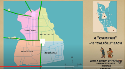
The City was connected to the main land by five great COSWAY's covered 13 square kilometer and was laid out in a dense grid of canals, roads and buildings
The city was divided into four quarters known as CAMP.
These were then further subdivided into 15 or so district known as CALPOLLI.
Each of these districts held commoner families led by set of nobles with their own market place, temple and school.
ROAD NETWORK:
From the Sacred precinct were four major roads, the east led to the docks of Tetamozolco while the North ,south and west led to the great cause waves Tacupa, Iztapalapa and Tepeyac leading to the main land.
The causeways were interrupted by bridges that allowed canoes and other water traffic to pass freely. The bridges could be pulled away, if necessary, to protect the city.The city was interlaced with a series of canals, so that all sections of the city could be visited either on foot or via canoe.
The causeways to the mainland were wide enough for ten horses side by side along each of this major Highways were located many of the larger city buildings with a series of gates and draw bridges located at the entrance of the city.


.png)
.png)


0 Comments